| Distance from SR 138 | Distance
From
I-210
(miles) | Time
From
I-210
(HR:MIN) | Mile Marker
(miles) | Location and Parking Info | Restroom
|
|---|
| 54.66 | 9.60 | 0:15 | LA 34.14 | Switzer Picnic Area, on right | yes
|
| 50.42 | 13.84 | 0:22 | LA 38.38 | Red Box, Mt. Wilson Road, on right | yes
|
| 45.50 | 18.76 | 0:30 | LA 43.30 | Shortcut Saddle, parking mostly on right | no
|
| 44.69 | 19.57 | 0:33 | LA 44.11 | 5000 feet elevation | no
|
| 41.30 | 22.96 | 0:39 | LA 47.50 | Charlton Flats Picnic Area, on left | yes
|
| 36.00 | 28.26 | 0:46 | LA 52.80 | Three Points Junction/Trailhead | yes
|
| 30.55 | 33.71 | 0:54 | LA 58.25 | Entrance road to Buckhorn Campground, on left | yes
|
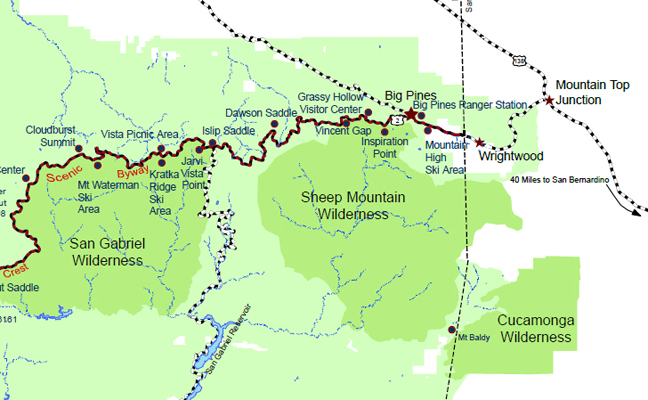
| 24.70 | 39.56 | 1:02 | LA 64.10 | Islip Saddle closed SR-39 is closed | yes
|
| 19.20 | 45.06 | 1:11 | LA 69.60 | Dawson Saddle, parking on left | no
|
| 14.00 | 50.26 | 1:20 | LA 74.80 | Vincent Gap, PCT parking, on right | yes
|
| 52.76 | 1:23 | LA 77.30 | Grassy Hollow Visitor Center, on left | yes
|
| 53.56 | 1:26 | LA 78.10 | Blue Ridge Summit Lightning Ridge and PCT, Blue Ridge Road, Inspiration Point | yes
|
| 55.36 | 1:27 | LA 79.90 | Big Pines Visitor Center, north side | yes
|
| 56.26 | 1:29 | LA 80.80 | Mountain High East Ski Resort, on south side | no
|
| 6.53 | 57.73 | 1:30 | LA 82.27
SB 00.00 | L.A. / S.B. County Line - Wrightwood | no
|
| 60.46 | 1:35 | SB 02.50 | Wrightwood | no
|
| 1.45 | 62.81 | 1:37 | SB 04.85 | 5000 feet elevation | no
|
| 1.30 | 62.96 | 1:39 | SB 05.00 | Boundary San Gabriel National Monument | no
|
| 0 | 64.26 | 1:39 | SB 06.20 | SR2 at SR138, Mountain Top Cafe | no
|
