 HIKE WRIGHTWOOD  WRIGHTWOOD SNOW PLAY  MH SLEDS  OUTDOOR REPORT  MOUNTAIN HARDWARE |
Angeles Crest Scenic Highway
Islip Saddleclickable map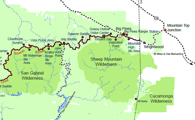
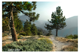
Islip Saddle, pronounced "eye-slip", is a 6,593' saddle located near the center of the San Gabriel Mountains between 8,214' Mt. Williamson on the northwest and 8,250' Mt. Islip on the southeast. That ridgeline is the Pacific Crest, separating the rivers of the coastal basin to the south that flow into the Pacific Ocean and the rivers flowing to the desert basins to the north. Drainage on the north slope goes to the South Fork of Big Rock Creek, thence to the Mojave Desert. Drainage from the south slope goes to Bear Canyon to the West Fork of the San Gabriel River. Islip Saddle has a large trailhead parking lot and is 40 miles from I-210 in La Cańada and 16 miles west of Big Pines along SR2, the Angeles Crest Highway. Islip Saddle is named for George Islip, who settled nearby in the 1880s. Access Map: Mt. Islip Region (IS marks the location, near the center of the map) See also: USGS 7.5' x 7.5' Map: Crystal Lake (34° 21' 25" N, 117° 50' 59" W) By Car: From Interstate 210, go northeast on Angeles Crest Highway, State Route 2, 40 miles about one hour driving time to mile marker 64.1. Access via State Route 39, San Gabriel Canyon Road, has been closed since 1978 between the Crystal Lake turnoff and Islip Saddle as a result of a major rock slide. Work has begun on reopening SR-39 from SR2 to just above Crystal Lake. Dave Anderberg reports that the security guard at the gate at Islip Saddle said that the road would reopen in 6 months to a year from now, although previous reports had given the opening date as 2004. Dave also observed many trucks and equipment working on the road on 20 October, making a 2000 date seem more likely. (Dave Anderberg 10/20/99) Pine Hollow Picnic Area to the east, that appears on some maps, has been dismantled. A Forest Adventure Pass is needed for parking. By Trail: West from Mt. Williamson or east from Little Jimmy Spring on the Pacific Crest Trail (PCT); west or east on the Silver Moccasin Trail from Mt. Baden-Powell (same as the PCT here), north from the South Fork Trail. An old Indian trail coming up from the West Fork and leading to Little Rock Creek once passed through Islip Saddle (The San Gabriels by John Robinson, page 4). Season: Open May to November or whenever SR2 is not closed by snow. Hike Notes: No. RT miles Elev. gain Season Name 65.1 5 1600 jun-oct Mt. Williamson from Islip Saddle, Angeles Crest Highway 70 10 2100 all South Fork Trail - South Fork Campground to Islip Saddle 77 7 1500 jun-oct Islip Saddle to Little Jimmy Campground and Mt. Islip 77.1 8 2300 jun-oct Islip Saddle, Little Jimmy Campground, Mt. Islip, Windy Gap Loop 77.3 13 (1 way) +3600-3700 jun-oct Islip Saddle to Windy Gap, Mt. Hawkins, Throop Peak, Mt. Baden-Powell, Vincent Gap Source: J. Strong & T. Chester |
Hiking TrailsIslip Saddle to Little Jimmy and Mount IslipMt. Islip (pronounced eye-slip) affords spectacular views over the San Gabriel Valley to the south and ...Islip Saddle to Mount WilliamsonMt. Williamson affords a spectacular view of the strange rock formations of the Devil’s Punchbowl, as ...Pacific Crest TrailIslip to CloudburstMiscellaneous photos of the PCT from the saddle to Cloudburst
|


|
Brought to you by Mountain Hardware Your full service hardware store Wrightwood California -- 12011 |